
Lake Sevan and Sevanavank Monastery: how to get there, what to see and when to swim
Lake Sevan 65 km from Yerevan: the M4 drive, Sevanavank Monastery, beaches, fish, prices and seasons. A practical guide for a trip by rental car.
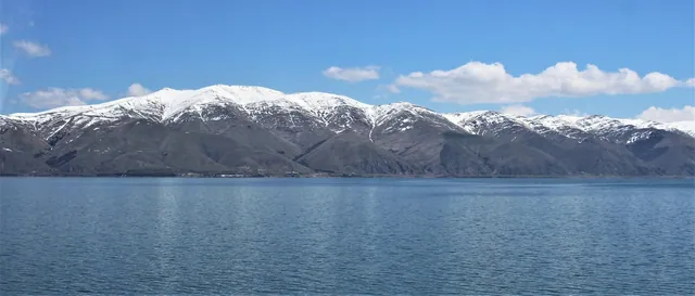
Lake Sevan lies 65 km from Yerevan, and the drive along the M4 highway takes about an hour. On a peninsula off the north-western shore stands Sevanavank Monastery, founded in 874, reached by a staircase of roughly two hundred steps. You can come year-round, but swimming is realistic only in July and August.
How long it takes to drive from Yerevan to Lake Sevan
Sevan is the largest lake in the Caucasus: an area of about 1,240 km² and a water surface at roughly 1,900 m above sea level. The difference in elevation from Yerevan is almost a kilometre, and you feel it immediately: by the water it is usually 8–10 °C cooler than in the capital.
Key distances from central Yerevan:
| Point | Distance | Driving time |
|---|---|---|
| Sevanavank (peninsula) | 65 km | ~1 h |
| Hayravank | 85 km | ~1 h 20 min |
| Noratus | 95 km | ~1 h 30 min |
| Dilijan via the tunnel | 100 km | ~1 h 30 min |
| Shorzha, north-eastern shore | 115 km | ~1 h 50 min |
| Full loop around the lake | ~200 km | 5–7 h with stops |
These times assume no traffic on the way out of the city. I usually leave Yerevan before eight in the morning: after nine, a solid column of trucks builds up on the climb from Abovyan to the pass, and the hour turns into an hour and a half.
A day route is easy to put together in the route planner; the spots around the lake are also on the map of places.
The M4 road and what to keep in mind behind the wheel
The highway from Yerevan to Sevan has two lanes in each direction for most of the way, and the surface is fine. The main difficulty is not the asphalt but the elevation gain: the road climbs from about 1,000 to 1,900 m, and on the long ascents trucks crawl along in the right lane.
Speed cameras are dense on this route, including on stretches where the limit drops sharply before villages. As a rough guide: 60 km/h inside settlements and 90 km/h outside them, with some sections marked differently. Check the signs for exact values, and look up current fines on the official resources of the Armenian road police.
Petrol stations along the M4 are frequent, gas ones included. Armenia has plenty of CNG and LPG cars, so methane and propane pumps exist even in small villages along the highway. If your rental car runs on gas, ask the rental company which type exactly and where the nearest station of the right standard is.
Mobile coverage along the M4 is steady almost everywhere. Dead zones start on the side turnings towards the northern shore and in the mountains beyond Artanish, so it is worth downloading offline maps in advance, over wi-fi back in Yerevan.
Sevanavank Monastery and the staircase up the hill
Sevanavank was founded in 874, funded by a donation from Mariam, daughter of King Ashot I Bagratuni. Two churches survive on top of the hill: Surb Arakelots (Holy Apostles) and Surb Astvatsatsin (Holy Mother of God). Both are small, built of dark tuff, with no interior painting. A few khachkars and the remains of monastic buildings stand nearby.
The climb up the stairs takes 5–10 minutes. There are around two hundred steps, wide and gentle, but at 1,900 m you run out of breath faster than usual. There is almost always wind at the top.
From the platform you see the greater and lesser parts of the lake at once. In the morning the water reads blue; by midday, with wind, it turns steel grey. The best light for photos is at sunrise and in the hour before sunset.
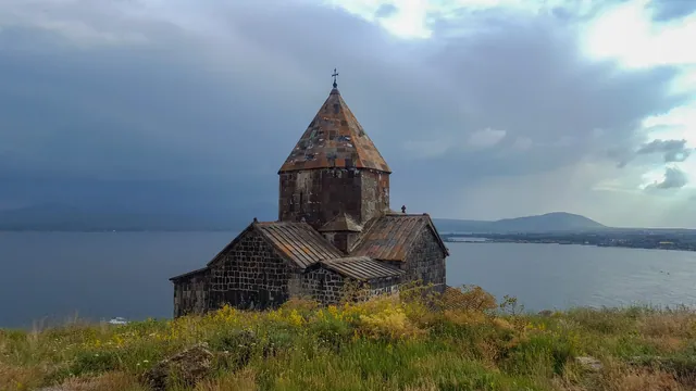
Entry to the monastery grounds is free, parking at the bottom is paid, a matter of a few hundred drams (2026 figures, amounts change). Cash comes in handy: there is not always a card terminal in the car park.
Crowds build between 11am and 4pm, when the coaches with group tours arrive. Once I turned up at half past eleven and spent more time looking for a parking space than on the monastery itself.
Why the peninsula used to be an island
Sevanavank was built on an island. Between the 1930s and 1950s the water level was lowered by roughly 19–20 metres: the lake was used for irrigation and hydropower, and the water drained through the Hrazdan river. The island joined the shore across an isthmus and became a peninsula.
Since the 2000s the level has been rising slowly, partly thanks to water transferred through a tunnel from the Arpa basin. The gain is measured in tens of centimetres a year, so in places the shoreline differs noticeably from older maps.
The practical consequence for a trip is simple. Some of the beaches marked in apps are now underwater or have shrunk badly, and a few buildings right at the water's edge stand half-flooded. Rely on what you see on the ground, not on a satellite image from three years ago.
On the exposed lakebed near Lchashen, Soviet-era excavations turned up bronze wagons and burials from the 2nd millennium BC. The finds themselves are kept at the History Museum of Armenia in Yerevan; there is not much to look at on site.
Hayravank and Noratus on the western shore
From the peninsula the road runs south along the western shore, through Gavar towards Martuni. The asphalt is patched in places, and speeds stay around 60–70 km/h.
Hayravank sits about 20 km south of Sevanavank, right above the water. A ninth-century church, small, almost always empty, with no parking fees and no souvenir stalls. The turn-off from the highway is short, some three hundred metres of dirt track in decent shape.
Noratus is the largest field of khachkars, carved stone crosses, in Armenia. There are around 900 of them, the earliest dated to the tenth century. The cemetery is open, entry is free, and there is no fence or ticket office. Walking the field takes 30–40 minutes.
A few practical details for this stretch:
- Over several trips between Noratus and Martuni I never managed to find a working ATM, so withdraw drams in Gavar or back in Yerevan.
- Village shops take cards only half the time, and markets are cash only.
- Sheep and cows wander onto the road, especially in the evening when the herds are driven back to the villages.
- The signs for the khachkars are small, and the turn in Noratus is easy to overshoot.
The northern shore, Artanish and wild beaches
The north-eastern shore is different from the western one: the mountains come closer to the water, there are fewer villages and more sandy stretches. The main points here are Tsovagyugh, Shorzha and the Artanish peninsula.
Decent asphalt runs as far as Shorzha. Beyond it, towards Artanish, the surface deteriorates, and the last few kilometres are a stony dirt road where a low sedan has no business going. A crossover handles it calmly, but slowly.
This is also where the fork to Dilijan begins. The new road goes through a tunnel about 2 km long; the old one climbs the Semyonovka pass at 2,114 m. The pass is prettier and roughly 20–25 minutes longer, and it is closed during snowfalls in winter. Before setting off in the cold season, check the road status on the website of Armenia's road department.
Beaches on the northern shore come in paid and wild varieties. The paid ones charge for entry and sunbeds and have a shower and a toilet; the wild ones have nothing at all, bins and shade included. It makes sense to carry an umbrella or a canopy: there is almost no natural shade by the water.
What the water in Sevan is like and when to swim
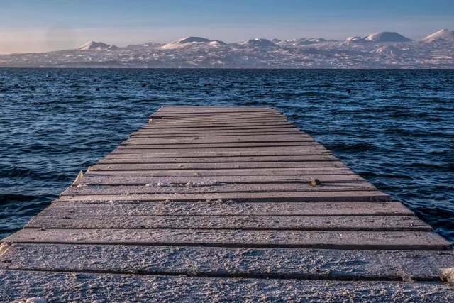
Sevan warms up late and not for long. In August the water temperature near the shore holds at about 19–22 °C, in July slightly lower, and in June it rarely climbs above 17. The rest of the year, swimming is a cold-water endurance exercise.
Wind matters more here than air temperature. Waves pick up almost every day around midday and usually die down by evening. (In late May the wind at the top was strong enough to whip the water into whitecaps, while Yerevan the same day had +30 and not a breath of air.)
A rough picture by season:
| Period | Daytime air | Water | What to keep in mind |
|---|---|---|---|
| May | +12…+18 | +8…+11 | Strong wind, green shores, few people |
| June | +18…+24 | +13…+17 | Water still cold, beaches half empty |
| July–August | +24…+28 | +19…+22 | Peak season, pricey rooms, weekend traffic |
| September | +17…+23 | +16…+19 | Warm days, clear water, quiet |
| October–November | +5…+15 | cold | For monasteries and views, not for the beach |
| December–March | −8…+3 | ice along the shores | Wind, black ice on the turn-offs, early dusk |
The figures are approximate and vary from year to year. In my experience, any trip to the lake calls for a windbreaker, even when Yerevan is at thirty degrees.
What to eat at Sevan
The main local fish are ishkhan, the Sevan trout, and sig, whitefish. Ishkhan is the pricier of the two and appears on menus less often; sig is served grilled almost everywhere. Crayfish are another local dish, boiled with herbs and brought out by the bucket.
Fish restaurants cluster at the entrance to the peninsula, along the highway near the town of Sevan, and here and there on the western shore. Expect a bill of around 4,000–8,000 AMD per person with fish (roughly 10–20 USD at about 390 AMD to the dollar, 2026 figures). Check the price per kilo before ordering: fish is charged by weight.
Roadside spots with barbecue and khashlama are cheaper, on the order of 2,500–4,000 AMD per person. Near the monastery they sell dried fish, gata and homemade cornelian cherry and walnut preserves.
Restaurants along the highway take cards almost everywhere; in the small village cafés on the western shore, count on cash.
The loop around the lake in one day
The full loop is about 200 km. It technically fits into daylight hours, but if you would rather not rush, pick one direction and come back the same way.
A workable day plan with an 8:00 start:
- Yerevan, out along the M4.
- Sevanavank, 9:00. The climb, the views, coffee at the bottom. One hour.
- Hayravank, 10:30. Twenty minutes to look around.
- Noratus, 11:15. Forty minutes across the khachkar field.
- Lunch in Gavar or on the shore near Martuni, 12:30.
- Back along the western shore, or continue the loop via the southern and eastern shores.
- Overnight option: turn off to Dilijan and stay there.
Going clockwise via the northern shore gives better views in the afternoon, because the sun will be behind you. Counter-clockwise is better for swimming: you will reach the beaches at Shorzha exactly when the water is at its warmest.
A one-day trip from Yerevan to Sevan and Dilijan and back comes to roughly 220 km and takes a full day with stops.
Is it worth renting a car just for Sevan
You can reach the peninsula without a car; the question is how many points you will manage to see. A comparison of the options for 2026, with approximate prices:
- Marshrutka from Yerevan's Northern Bus Station. Around 1,000–1,500 AMD one way, departing when full. It takes you to the town of Sevan, leaving about 4 km to the monastery, then on foot or by hitching a ride.
- Taxi through an app. Somewhere around 8,000–13,000 AMD one way; catching one back is harder, as drivers are reluctant to wait.
- Group tour. Usually Sevan plus Dilijan or Garni, about 15,000–25,000 AMD per person, with a rigid schedule and 40–50 minutes on site.
- Car rental. Your own timetable and the option to stop at Hayravank and Noratus, where public transport barely goes.
The difference shows up on the western shore: the khachkars of Noratus and the church at Hayravank sit away from the bus lines, and getting there without a car means a long trip with transfers. Car rental in Yerevan is worth pricing for a couple of days at once if you are planning Sevan plus Dilijan. Check in the contract whether driving on unpaved roads is allowed: the turn-offs to the wild beaches and to Artanish are exactly that.
Coming back from Dilijan to Yerevan in the evening is easier through the tunnel than over the pass: fewer curves and better lighting on the way out.
Frequently asked questions
How much does entry to Sevanavank Monastery cost? Entry to the monastery grounds is free; you only pay for parking at the bottom of the staircase, usually a few hundred drams. Amounts change, and cash is more reliable than a card. There is no ticket office or ticket as such, and visiting hours are effectively limited to daylight.
Is one day enough for Lake Sevan? For the peninsula with the monastery and one or two points on the western shore, a day is enough: that is roughly 200 km of driving and 5–7 hours with stops. A full loop around the lake with a swim and lunch is better stretched over two days, with a night in Dilijan or on the northern shore.
Are there gas stations on the way to Sevan? Yes, CNG and LPG stations appear along the M4 and in the villages beside it, as Armenia's car fleet runs on gas to a noticeable degree. Ask the rental company in advance which fuel your car takes. On the side turnings towards the northern shore the choice of stations drops sharply.
Is the road around Sevan open in winter? The main M4 and the ring road around the lake are cleared and open, and traffic in winter is normal. The problems come on the Semyonovka pass and on the turn-offs down to the shore: black ice, snowdrifts, strong crosswinds. Check road status before setting off on the road department's resource.
Where can you stay overnight by the lake? There are hotels and guest houses in the town of Sevan, in Tsovagyugh, in Shorzha and on the western shore near Gavar. Prices rise in July and August, so book ahead. Many beach resorts operate only in the warm season and close by October.
What matters most
Lake Sevan is convenient because it fits into a single day from Yerevan without feeling like a box ticked: the peninsula, the khachkars of Noratus and the empty shore at Hayravank give you three different pictures within 40 km of each other. Bring cash, a windbreaker and a full tank: there are almost no ATMs on the western shore, the wind picks up daily, and the choice of petrol stations off the M4 narrows fast. Swimming makes sense in July and August; the rest of the year people come here for the drive and the monasteries.